
Discovering the Old Route Over Blewett Pass
When driving the bottom of Blewett Pass - (only attempt this if you’re the passenger), look off to the highway's right, just after the double lane merges back to a single lane.
You'll see it.
A small, narrowly paved road follows alongside modern-day Blewett Pass.
I’ve seen this weathered, narrow paved road appearing at the bottom end of the original “Old Blewett" route and wondered about it.
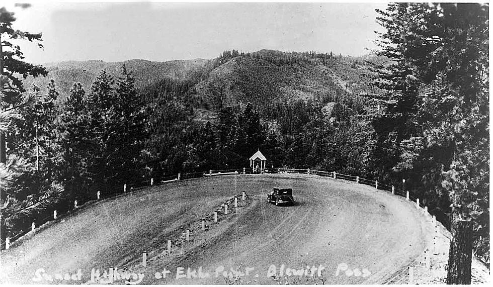
'A clip of the old Blewett Pass highway, featuring a viewpoint with a view of the current highway. ' - Kevin Ohme
Kevin Ohme was kind enough to post the video of the bottom section (Forest Service Road 7312) on Facebook for The Wenatchee Valley History group.
The video prompted a Facebook comment from Dave Helgeson, who asked: “I assume you hiked up from Ingalls Creek?” (Ingalls Creek Trailhead)
Kevin's reply, “Yes.”
I looked up the route on Google Maps, and the mysterious path suddenly made sense - all thanks to Kevin's video.
A forest service road path leaves the Ingalls Creek trailhead and crosses a bridge over Ingalls Creek. Forest Service Road 7312 continues alongside the lower section of modern-day Blewett Pass and connects with Old Blewett Pass at Scotty Creek using Forest Service Road 9715 to the Swauk Campground.
Blewett Pass was born.
Beginning in 1915, the original Sunset Highway connected Renton to Spokane via Snoqualmie Pass.
After traveling up and over the Cascades, it continued east to Vantage via Ellensburg. The route eventually made its way to Wenatchee with the help of a couple of ferry routes. From Wenatchee, the Sunset Highway traveled across the black pedestrian bridge into East Wenatchee. It continued up Pine Canyon to Waterville, then points east to Spokane.
Click this link to read more about the early days of Sunset Highway.
In 1922, the Sunset Highway was improved, and the route changed. After reaching Cle Elum from Seattle, the new route went north over Blewett Pass (what today is known as Old Blewett Pass, seen below) to Peshastin and then east to Wenatchee.

Modern-Day Route of Blewett
In the 1950s, the 1920s era highway improved and widened.
The crossing over the pass was changed from above the Swauk Campground to what is now the summit of Blewett Pass.
Much of the old road (Old Blewett) was bypassed and left in place for local access to cabins and outdoor enthusiasts.
The map of the new route referred to the summit of modern-day Blewett Pass as - Swauk Pass.
'Blewett Pass was named for Edward Blewett, a Seattle mining promoter of the 1880s, it lies on the route of the historical Yellowstone Trail.' -Washington Mile by Mile
From the 1960s to 1990, Highway 97's summit area was known as Blewett-Swauk Pass.
Some map publications called it the Swauk-Blewett Pass.
Swauk Pass
For two short years, 1990-1992, the summit of Highway 97 was Swauk Pass.

'That was when the U.S. Board on Geographic Names – the official body managed by the U.S. Department of Interior to keep track of place names – got involved and took formal action in 1992.' - KIRO Newsradio
Blewett Pass has remained on its current route and identity - ever since.
Info: sunset-hwy.com, KIRO Newsradio, Wenatchee Valley History (Facebook Group)
The 5 Best Places To Pick Delicious Apples in Washington State
Gallery Credit: Rik Mikals
The Top 5 Most Surprising Stressful Jobs in Washington State
Gallery Credit: Rik Mikals
More From KW3